Hai Duong Province
Sightseeing
Overview
HAI DUONG PROVINCE
Square: 1,652.8 km2.
Population: 1712,8 thousand people (2010)
City: Hai Duong City
Districts: Chi Linh, Nam Sach, Thanh Ha, Kinh Mon, Kim Thanh, Gia Loc, Tu Ky, Cam Giang, Binh Giang, Thanh Mien, Ninh Giang.
OVERVIEW
Hải Dương city is bordered to the northeast by the Nam Sách District and Thanh Hà District. A branch of the Cái River (literally, "mother river" in Vietnamese) divides the city into two parts, on one side the urban area, on the other side lie rural and industrial outskirts. It is bordered to the west by the Cẩm Giàng District, and to the south by the Gia Lộc and Tứ Kỳ districts, and also a branch of the Sat River. The city is located in the centre of both the Northern Economic Area and of the Hanoi–Hai Phong–Quang Ninh development region as well. Hải Dương is located 58 kilometres from Hanoi, 45 kilometres from Hai Phong, and 80 kilometres from Halong Bay. A railway, National Highway No.5 and National Highway No.18 all pass through the province.
HISTORY
- Hai Duong is located in the Red River Delta where originated from civilization of Red River. Hai Duong has had many changes in names throughouts history.It was a part of Duong Tuyen (in the period of King Hung), Giao Chi and Giao Chau ( in the 1st millennium); Nam Sach Lo, Hong Lo (under period of Ly and Tran dynasty); Hong Chau, Nam Sach (in the 16th century); Thua Tuyen, *Hai Duong (in the 10th year of Quang Thuan King).
- Hai Duong province was established in 1831 and was first called “ Thanh Dong” ( East Province) which mean “ the city to the east of Thang Long citadel”.
- In the early 20th century, the patriotic movement was expanded in Hai Duong.
- In 1930s, Hai Duong people carried out two resistance wars against French imperial and American emperor and then won victories.
- In 1968, Hai Duong was merged to Hung Yen to become Hai Hung province.
- In January 1997, Hai Hung was separated in to Hai Duong and Hung Yen.
- In August 1997, The Government decided to upgrade Hai Duong from town to city. Since 1997, Hai Duong has had 11 districts and a city.
GEOGRAPHY
Hai Duong is on the Red River Delta. It borders with Bac Ninh, Bac Giang provinces on the north, Hai Phong, Quang Ninh provinces on the east, Hung Yen Province on the west, Thai Binh Province on the south. The network of rivers includes Thai Binh, Rang, Kinh Thay, and Dao rivers' giving good condition for agriculture and water transportation.
CLIMATE
Hai Duong lies in tropical monsoon climate. The annual average rainfall is 1300 - 1700mm. The average temperature is 23.4ºC.
TOURISM
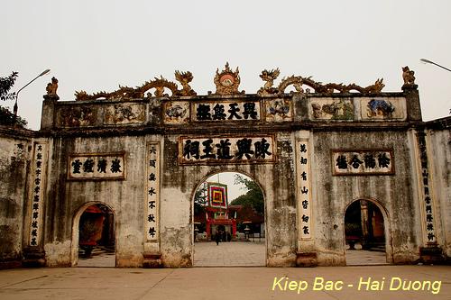
Long-standing history bequeaths hundreds of cultural, historic relics. They are Phuong Hoang, Kinh Chu An Phu sites, Con Son, Thanh Mai, Hun pagodas, Nguyen Trai, Cao, Kiep Bac temples, Gieng Ngoc (Pearl Well), Thach Ban (Flagstone), of which Con Son - Kiep Bac are most popular ones.

Hai Duong is close related with many celebrities such as Le Huu Trac, Tran Nguyen Dan, Nguyen Trai, Mac Dinh Chi, and Pham Su Manh.
The province is proud of traditional handicraft villages like Chu Dau Pottery, Chau Khe Gold, Dong Dao Carving, Ke Sat Dry Pancake and Hai Duong Green Bean Cake. Folk songs like ca tru, cheo, xam are commonly here.
In addition of these, tourists also take interest in Chi Lang Nam Stork Village, home of thousands of white, black, fiery stocks, herons and egrets.
TRANSPORT
The network of road, railway and river-way transportation is convenient. The province lies on railway and National Highway No.5: Hanoi - Hai Duong - Hai Phong, on National Highway No.18: Bac Ninh - Hai Duong - Quang Ninh. Cong Cau river- port has a total capacity of 300,000 tons per year.
Hai Duong is 58km from Hanoi, 45km from Hai Phong, and 80km from Halong Bay.

