Quảng Trị
Sightseeing
Overview
QUANG TRI PROVINCE
Square: 4747,0 km2.
Population: 600,5 thousands people (2010)
City: Dong Ha City.
Districts: Vinh Linh, Gio Linh, Cam Lo, Trieu Phong, Hai Lang, Huong Hoa, Da Krong, Con Co.
OVERVIEW
Located on North - Central Vietnam, Quang Tri is surrounded by Quang Binh Province on the north, Thua Thien-Hue Province on the south, Savanakhet (Laos)on the west, East Sea on the east with 75km seaside. Topography consists of mountains, hills, plains, sand dune and seaside. The long coast and complex network of rives includes Ben Hai, Cam Lo, Quang Tri, Thach Han… making a good condition for hydroelectricity and aquiculture.

HISTORY
In the immediate prehistorical period, the lowlands of Quang Tri and Central Vietnam as a whole were occupied by Cham peoples (Champa), speaking a Malayo-Polynesian language, and culturally distinct from the Vietnamese to the north along the Red River. The Qin conquered parts of present day Central Vietnam at the end of the 3rd century BCE, and administered the indigenous peoples of the area through a commandery, Rinan, for several centuries. A rebellion by the Cham in the 2nd century CE overthrew Chinese control and reestablished local government. 136 Beginning in the 14th and 15th centuries, the Chams were defeated in the area by Vietnamese armies, and ethnic Vietnamese gradually displaced or absorbed those Chams who had not fled. Over time a distinct Vietnamese dialectical and cultural subgroup developed in the area. The region was seized by the French by 1874 and became part of French Indochina in 1887 as the Annam protectorate.
Upon the division of Vietnam in 1954 into North and South, Quang Tri became the northernmost province of the Republic of Vietnam. Starting in 1964, the province gradually became a center for American bases, particularly after October 1966, when the 3rd Marine Division moved to bases just south of the demilitarized zone. In 1966, North Vietnamese forces also began occupying the northern region and pushing deeper into the province. The provincial capital, Quang Tri City, was overrun and occupied briefly by Communist troops in April, 1967, and was a principle battleground during the 1968 Tet Offensive when it was again overrun by North Vietnamese troops and held for a short period before being recaptured by South Vietnamese government and U.S. forces.The well known Battle of Khe Sanh (1968) was a part of the North's steady efforts to occupy the whole of the province.
After Khe Sanh was evacuated in July 1968, the North Vietnamese continued their efforts to take the entire province. The most notable achievement of the North Vietnamese offensive in 1972 was capturing Quang Tri (First Battle of Quảng Trị), though they lost much of the territory gained during the South Vietnamese counteroffensive June through September, 1972 (Second Battle of Quang Tri). With South Vietnamese forces unable to hold the province during the final North Vietnamese offensive of the war (Ho Chi Minh Campaign), the entire province fell to North Vietnamese forces in March, 1975.
After Quang Tri fell, the North Vietnamese Provisional Revolutionary Government laid its authority over the province. Collective farms were set up and strict rules instilled by the Viet Cong were forced on the villagers, many of whom eventually fled. According to Gary D. Murfin, one of the lead writers to have done a survey on Vietnamese refugees after 1975, the province was an area of particularly dense Catholic concentration, many of whom were anti-communist. He estimated that 41% fled the area in fear of Viet Cong reprisals, 37% feared fighting, shelling, and bombing, and others fled because they were a family related to a Nationalist soldier, or were at one point landowners. Today, the province is largely agricultural and rural.
The provincial capital of Quang Tri is Dong Ha. Another notable town is Quang Tri, a new settlement built across the Thach Han River from the former provincial capital, Quang Tri City, which was destroyed during the war.
GEOGRAPHY
Located on North - Central Vietnam Quang Tri is surrounded by Quang Binh Province on the north, Thua Thien-Hue Province on the south, Savanakhet (Laos)on the west, East Sea on the east with 75km seaside.
Topography consists of mountains, hills, plains, sand dune and seaside. The long coast and complex network of rives includes Ben Hai, Cam Lo, Quang Tri, Thach Han making a good condition for hydroelectricity and aquiculture.
CLIMATE
The weather condition is very severe with hot and dry south- west winds. Annual average temperature is 24ºC.
TOURISM
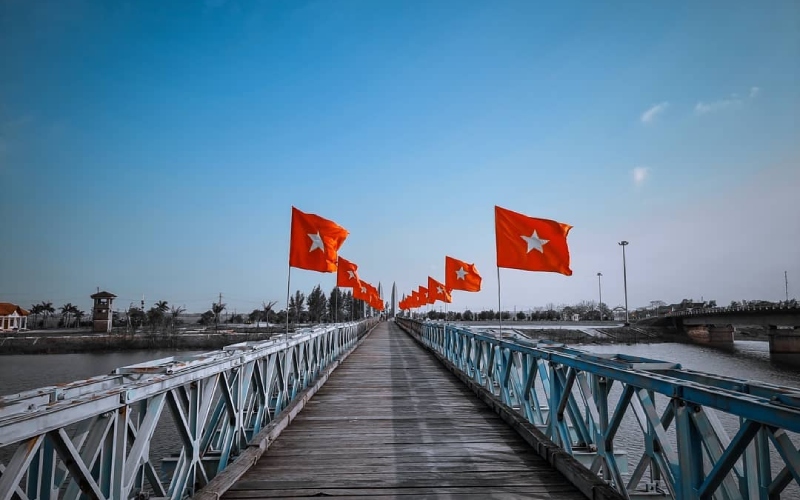
Quang Tri preserves many remains from the anti- American resistance war such as the ancient citadel of Quang Tri, Khe Sanh Combat Base, Truong Son National Cemetery, Vinh Moc Tunnels, Hien Luong Bridge and Ben Hai River.
Coming to there, tourists are able to take interesting holiday in Dakrong Beauty Spot and Cua Tung Beach. The beach has sparkling clean water, silky sand and soft breeze, the whisper made by the rows of casuarinas trees. It is very pleasant to go on boat down stream on the Ben Hai River and admire the beautiful landscapes.
TRANSPORT
Dong Ha Town is 74km from Hue City, 80km from Lao Bao Border crossing, 94km from Dong Hoi (Quang Binh Province), 190km from Da Nang, 617km from Hanoi, and 1,112km from Ho Chi Minh City . National Highway No.1A runs through the province and National Highway No.9, the Trans-Asia Highway connects with the Lao Bao international border gate to Laos

